A vanished city lives again...

Monday, March 30, 2009

A prelude to terror


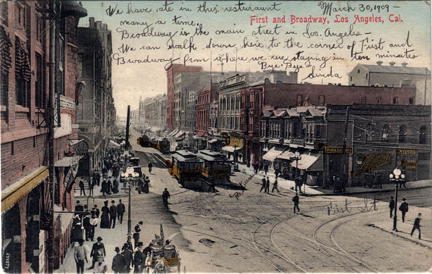
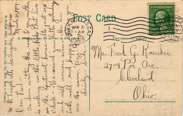
One century ago today – indeed, 100 years to this very hour – this postcard was penned in a long-vanished boarding house at Temple and Figueroa Streets in Los Angeles, and addressed to a now also non-existent residence in Cleveland, Ohio...


In 1909, the intersection of Broadway and First Street was the center of civic life in old Los Angeles. Today, however, absolutely nothing you see in this postcard still exists. Old San Francisco was destroyed by its famous earthquake and fire of 1906, most of Chicago was wiped out by its own Great Fire of 1871, but old Los Angeles was even more thoroughly destroyed by the hand of man himself.



In 1910, however, another kind of destruction would visit Broadway and First, when the building to your immediate left (you could almost reach out and touch it from this vantage point) would be dynamited into fiery rubble in the third most murderous act of domestic terrorism in the first half of the 20th century. Only the Wall Street bombing of 1920 and the Bath School bombings of 1927 produced higher death tolls than this anarchist attack in Los Angeles in 1910.

And yet, I doubt that even 1 out of 10,000 of the present-day residents of L.A. know about the horrific bombing that took place in their own city less than a century ago. I didn't, myself, before the history of pre-WWII Los Angeles became an avocation of mine a few years back.

I'll have more to say about the bombing at its centennial in October of next year...
 

Thursday, March 26, 2009

Old city center: Then and Now

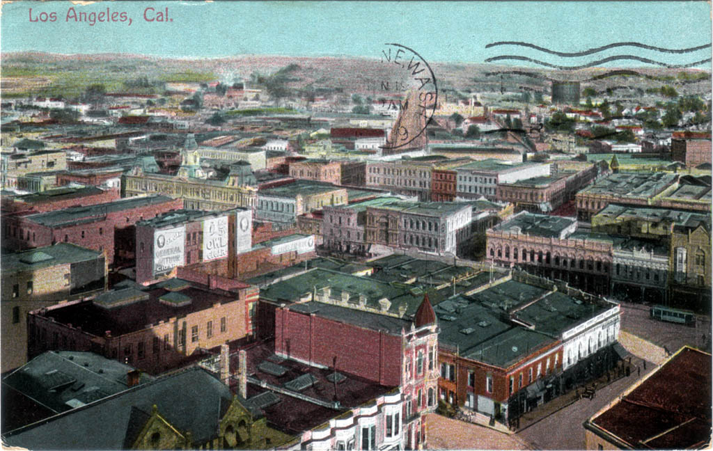
Two superb postcard scores within a week! The top one is a rare view of Los Angeles taken around the turn of the last century from the top of the old County Court House, looking east-northeast.


At far right is Temple Square: the heart of the city at the turn of the last century. The street car is running on Main Street. The wide dirt road by the semi-circular postmark is Aliso Street, and the narrower road running parallel to it at right is Commercial Street.

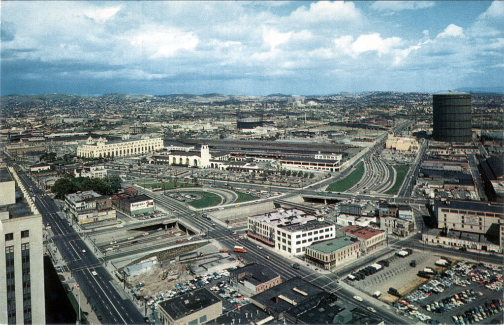
Now, here's roughly the same east-northeast view a half-century later.


This photo was taken from the top of the present City Hall at the SW corner of Temple and Main (out of the picture to the right of where the street car is in the earlier view). Aliso Street has been replaced by the 101 freeway; Commercial Street runs just to the left of the large natural gas storage tower and to the right of the yellow Brew 102 brewery.

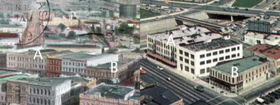
In the 1950s view, the street running from side to side in the lower center of the picture is Los Angeles Street. Two buildings on the east side of Los Angeles Street appear in both postcards. Can you spot which ones?

Here they are...

Buildings "A" and "B" on Los Angeles Street survived at least into the 1950s.


Neither structure still stands today, however.


Thursday, January 15, 2009

New treasures!

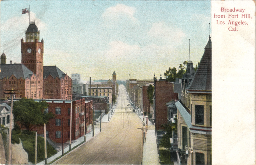
Last month, I got this neat old postcard of Broadway near its intersection with Temple Street. The photo was taken from the top of the south entrance of the Broadway Tunnel. The design of the reverse side of this Rieder postcard indicates it was printed between 1907-'08. The photo, however, dates to approximately 1903. The Braly Building (1902-'03) can be seen in the distance, just to the right of the Court House. The scene can't be later than 1904, though, otherwise the Hotel Lankershim would be visible at the far end of Broadway.


This is one of my absolute favorite views of the vanished city. I just feel totally at home here, gazing at this simple scene...


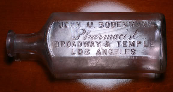
Then, last week, this old medicine bottle showed up on eBay. Broadway & Temple! Holy crap! I just had to have it. And, as of today, I do!


Photo by J Scott Shannon.

I know a little bit about antique bottles, and this one definitely dates to pre-1915. So, it's essentially contemporaneous with the postcard view! I wonder which of the three possible corner buildings housed the Bodenmann pharmacy. I will find out eventually, I'm sure!


Sunday, November 9, 2008

Lost in time...

I've gone nuts, I really have. I am truly lost in time...

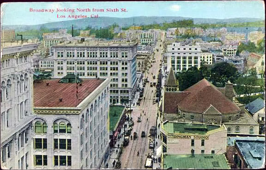
This old postcard showed up on eBay the other day in the Los Angeles category. As you can see, it says it's "Broadway looking North from Sixth St." But right away, I thought, that's weird, if this is Broadway looking north from Sixth, then why can't I see old City Hall, or the County Court House on Pound Cake Hill? No, this can't be Broadway. Is it even Los Angeles? Yes, it is, absolutely. The square white building at right center is definitely the Pacific Mutual Building at Sixth and Olive Streets.


OK, so where exactly in old Los Angeles is this, then? Well, first of all, we are obviously looking west on Sixth. That's Central Park there at right (now Pershing Square), so that would be Hill Street at the east edge of the park, then coming this direction, the unseen street in front of us would be Broadway. That means the picture was taken from a location on Spring Street, and, judging by the angle and perspective, that vantage point would almost have to be the Los Angeles Trust and Savings Bank at the northwest corner of Sixth and Spring. That's it! So, this postcard is actually "Sixth Street looking West from Spring St." And the date? It's postmarked 1912, and the L.A. Trust & Savings building... I believe that went up in 1910, so yeah, I'd say the photo for the postcard was probably taken then, in 1910.

Then I stop and think – I can recognize where I am in Los Angeles a century ago with perfect precision, but if I found myself at the same spot in downtown L.A. in 1999 (the last time I was there), I would have been almost completely lost.

What's funny is, I've acquired all this knowledge about the streets and buildings of old L.A. simply by casually viewing old images and maps I've found in online archives in only the last year or so. I've never actually sat down and studied any of this. I've just passively absorbed all this information, and have reconstructed most of turn-of-the-last-century Los Angeles in my imagination. These imaginings are so vivid now, they almost seem like real memories sometimes. It's so strange to feel so at home in a place and time as far away as this. Strange, but wonderful, too!


Thursday, September 25, 2008

"Best lighted Street in the World."

While on the subject of street lighting, I'd like to share what is probably my favorite postcard of old Los Angeles: this view of Broadway from First Street. Note the caption. Broadway is said to be the "Best lighted Street in the World." Although the card was mailed in 1907, I believe the image itself may be about a decade older, from around the turn of the last century (due to the conspicuous absence of automobiles).


I love this card mostly because the detail in it is amazing – it really brings the old city alive for me. Broadway was both the commercial center of Los Angeles and the seat of its government. (The tall Romanesque campanile with the pyramidal top is the bell tower of the old City Hall, built in 1888 – at that time, the tallest structure in Los Angeles.) Sadly, as with my even older postcard of Spring Street, not a single structure visible on this Broadway postcard remains standing today.

Here is the same view today. What was once a bustling downtown street filled with people, commerce and civil life is now a home only for sterile monolithic buildings.


View Larger Map


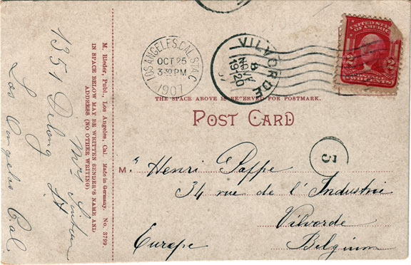
The postcard itself has an interesting story to tell. It was originally mailed to Belgium, and as you can see, it took almost a month to get there; traveling as it must have by sea.


In Europe, the postcard somehow survived two World Wars, made its way to the Netherlands where I bought it from an eBay seller there, and in the 21st century, the postcard is now back in California, with me. ^^

Now, see where the person who sent the card lived, and what's there today...

I can't quite decipher the name of the sender. It looks something like "Mrs. Linton," but her address is clearly "1351 Delong St."; note her 1s written in the European style.

Well, Delong Street is another of those vanished residential L.A. streets, like Palm Drive. And actually, Delong turns out to be walking distance from Palm Drive, in what was generally a very nice old out-of-the-way part of town.


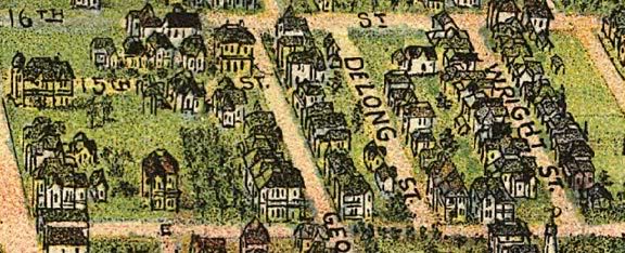
Here's a view of Delong from an 1894 "bird's eye" map of Los Angeles.


We're looking towards the south here. In L.A., odd numbered addresses are on the west sides of streets, so 1351 would probably be the house immediately to the right of the "S" in "ST.", or maybe the small green one up and to the right of the "S."

Anyway, here's an aerial view of the neighborhood today, and a Google Maps Street View image. Delong Street is now occupied by the Los Angeles Convention Center...


Google Earth.


View Larger Map

Where «34 rue de l'industrie» is in Vilvorde, Belgium, though, I wasn't able to determine. Like Delong St. in Los Angeles, it, too, is likely no more...


Sunday, September 21, 2008

Birthday postcard

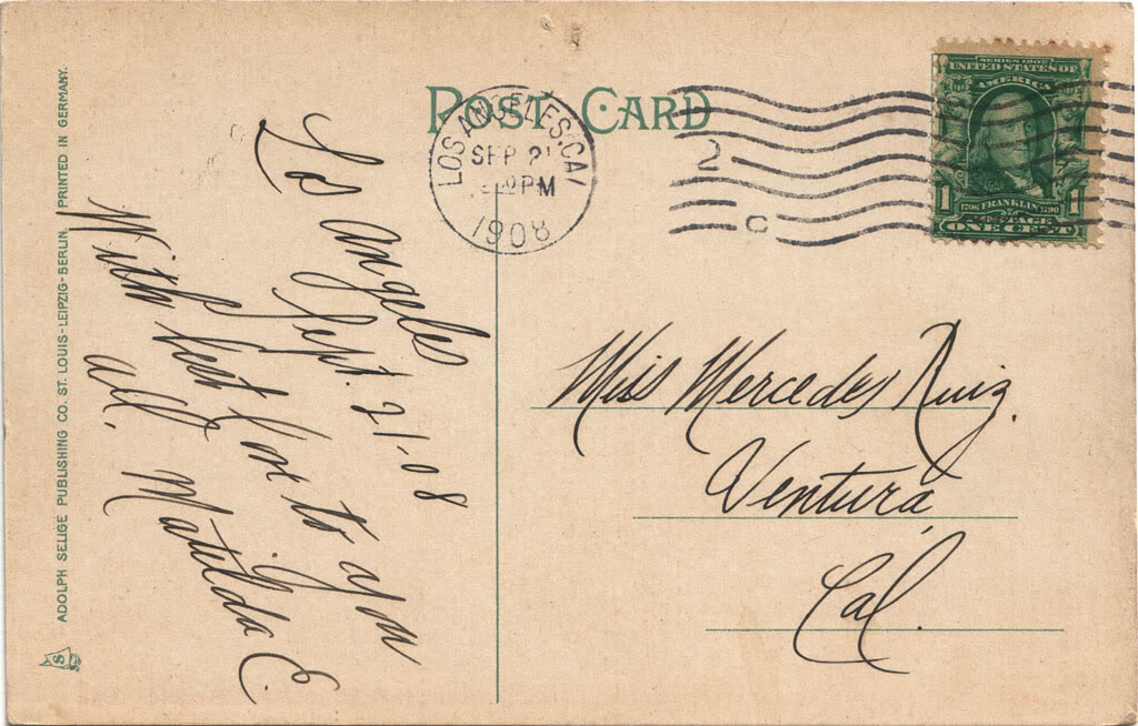
Got an unexpected surprise via eBay the other day: an old postcard mailed exactly 100 years ago today, and 46 years before I would be born.

It features a really nice view of the old L.A. County Court House, too; probably the nicest in my postcard collection.


Lovely penmanship...