A vanished city lives again...

Showing posts with label maps. Show all posts

Monday, February 25, 2013

The 1924 Olmsted "Major Traffic Street Plan"

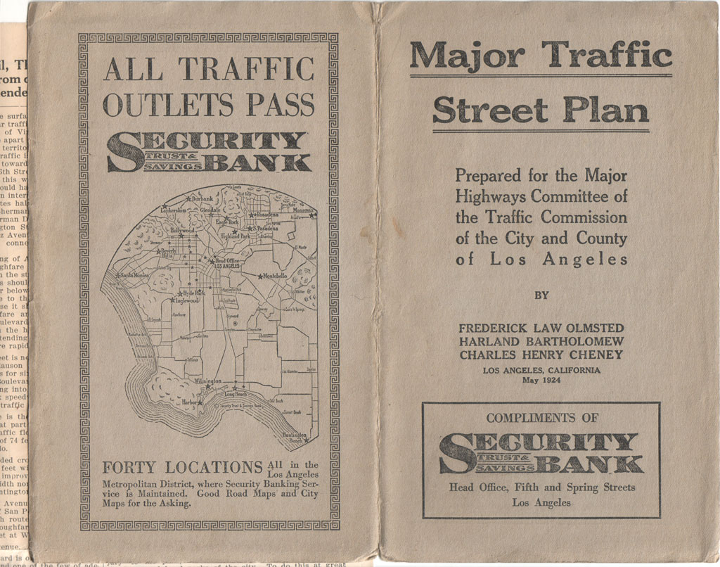
This recent post by Glen Creason on Los Angeles Magazine's City Think blog introduces readers to Frederick Law Olmsted, Jr. et al.'s grandiose "Major Traffic Street Plan" of 1924.

I first acquired this map out of curiosity, mostly because some of the street routes and parkways proposed in it looked significantly different than the ones Los Angeles eventually ended up with.

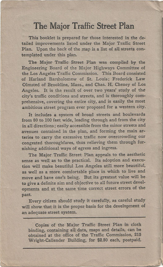
Here's the basic mission statement of the plan.

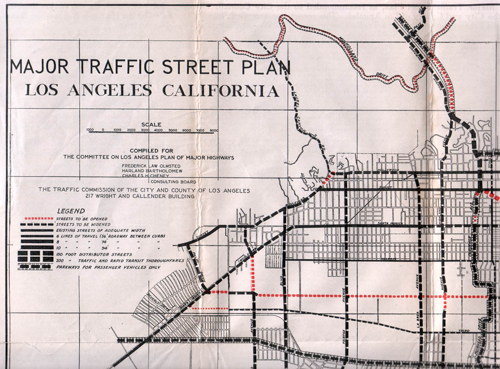
The legend (the map is far too large for me to scan in its entirety, unfortunately):

Several new scenic arteries were proposed, one of which was to be called "Arroyo Seco Parkway" (described in the plan as a "radical thoroughfare"). That and "One Hundredth Street" (Century Boulevard) seem to be the only major roads from this plan that ended up being built, though.

One of the rejected proposals was for the Downtown portion of First Street to be widened to 150 feet, and then extended northwest up to Hollywood – clearly a 1924 approximation of what would become the Hollywood Freeway a generation later.

Another interesting proposal was a road called the "River Truck Speedway," which was to run somewhat adjacent to the Los Angeles River and was intended solely for use by commercial vehicles. Obviously this idea didn't get past the drawing board stage, either.

Other proposed roads that were never realized were the "Hollywood-Palos Verdes Parkway," the "Silver Lake Parkway," and parkways for portions of Wilshire Boulevard (west of Crenshaw), Cahuenga Avenue, Riverside Drive, Franklin Avenue/Los Feliz Boulevard, Griffith Park and Mulholland Drive.

The Olmsted plan was admittedly visionary in foreseeing the need for wide urban roads that incorporated a variety of modes of rapid transit, but it was probably for the best that it was not adopted. The present system of freeways, although not without its own inherent problems, turned out to be a much better fit for Los Angeles's ever-evolving traffic challenges.


Saturday, November 24, 2012

1891 Landmarks

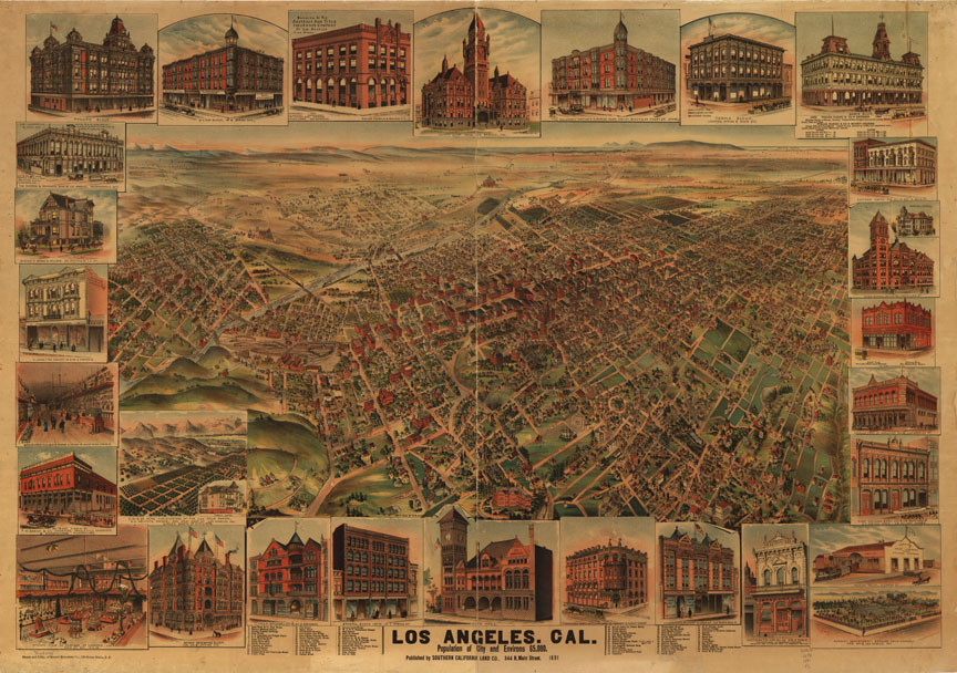
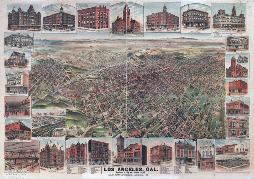
Apologies for the hiatus. Seemingly endless computer snafus and trainwrecks in my personal life have kept me from spending more time indulging in my favorite avocation. Anyway, recently, I used Photoshop to do a little color mod of this panoramic map of Los Angeles from 1891. The highly-foxed original image cleaned up rather well, I think!

Before:

Library of Congress.


After:

Library of Congress.


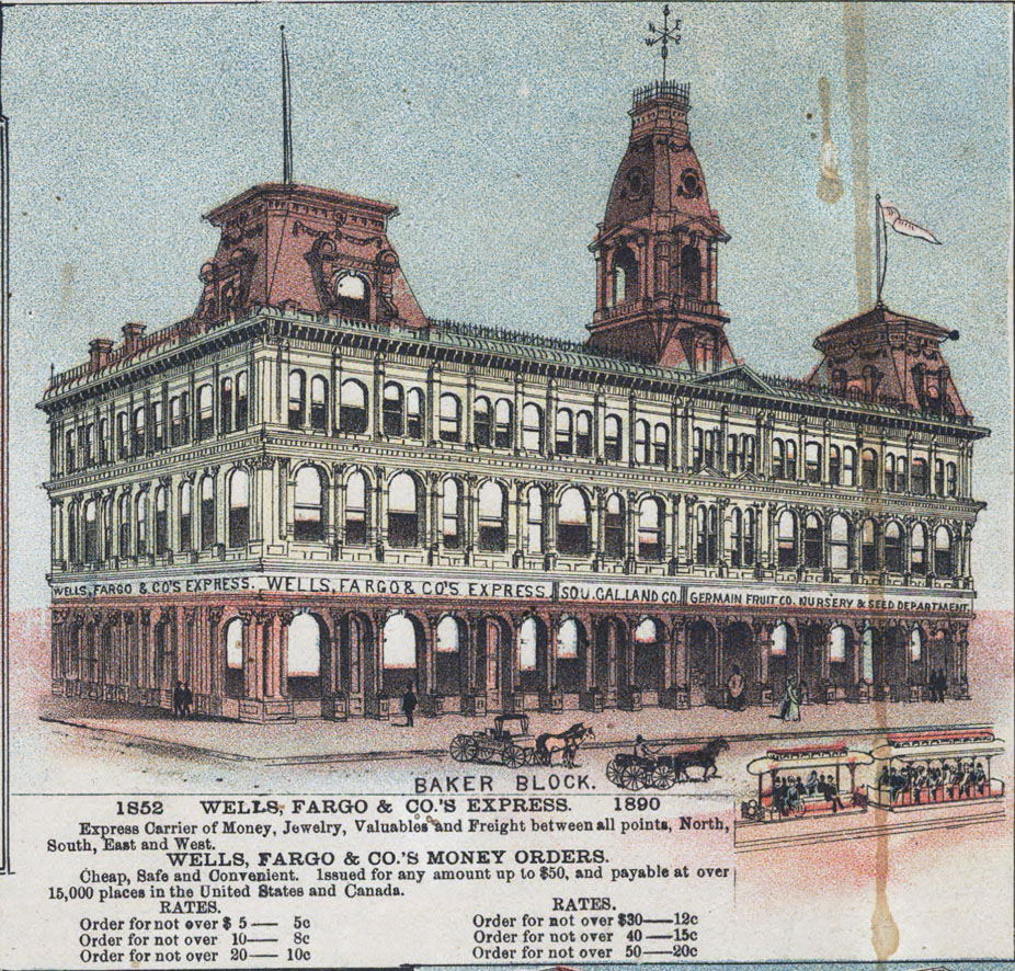
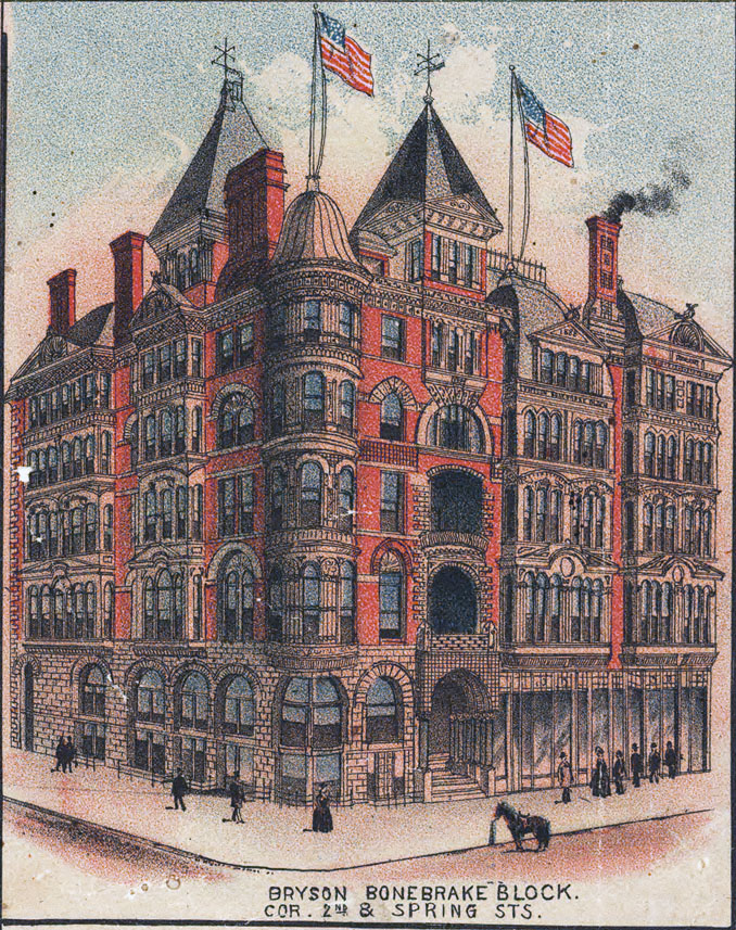
The buildings depicted in the margins are worth a much closer look.


Library of Congress.


Library of Congress.


8 more behind the jump!

Tuesday, October 2, 2012

The oldest building in Los Angeles?

Many have already heard about the emerging realization that the Sanchez Adobe in the Baldwin Hills may be the oldest building in Los Angeles.

Although the structure bears the Sanchez name, it is believed to have actually been built by unknown rancheros fifty years before the land was first deeded to Don Vicente Sanchez in 1843.

This 1840s map depicting the boundaries of "Rancho del Paso de la Tijera" shows the little cottage whose existence has now spanned four centuries.


Hispanic-Heritage Links at the National Archives.


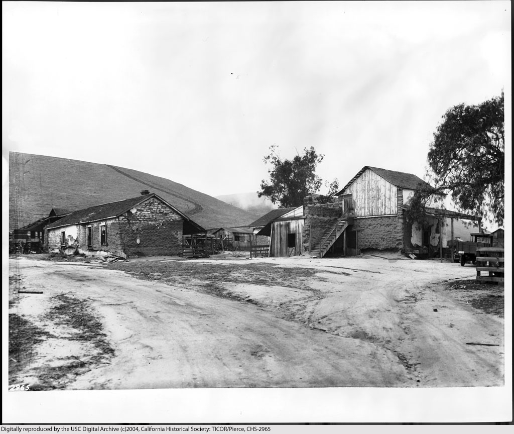
The former Baldwin Ranch, circa 1926. The Sanchez Adobe is the taller white building to the left of center.


Courtesy U.S.C. Digital Library.


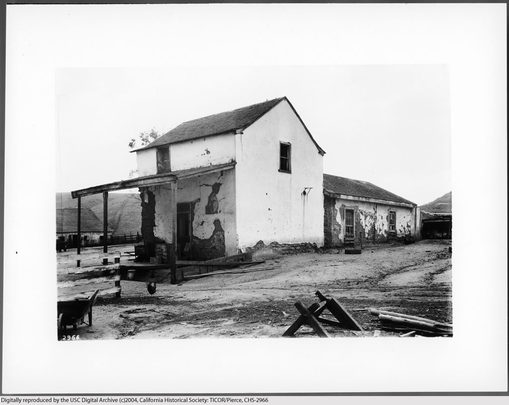
Casa de Sanchez, ca. 1924. At this time, the house was already 130 years old.


Courtesy U.S.C. Digital Library.


Another view of the Sanchez house (right) in the 1920s. Does the adobe outbuilding at left still survive? A modern aerial view suggests a possibility that it may.


Courtesy U.S.C. Digital Library.


Only a few years later, the two-storey Sanchez house was incorporated into a much larger modern structure that still stands today at 3725 Don Felipe Drive.


Courtesy U.S.C. Digital Library.


Wednesday, August 10, 2011

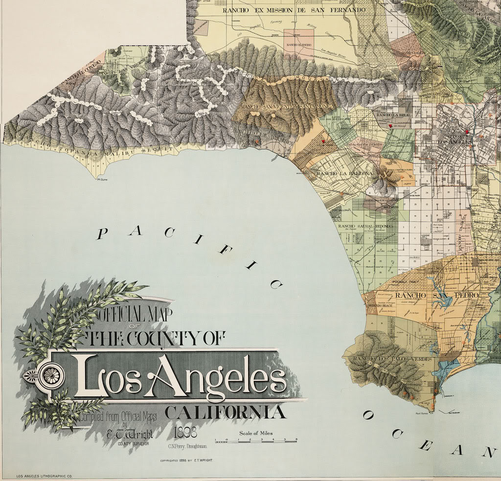
Rancho lands in 1898

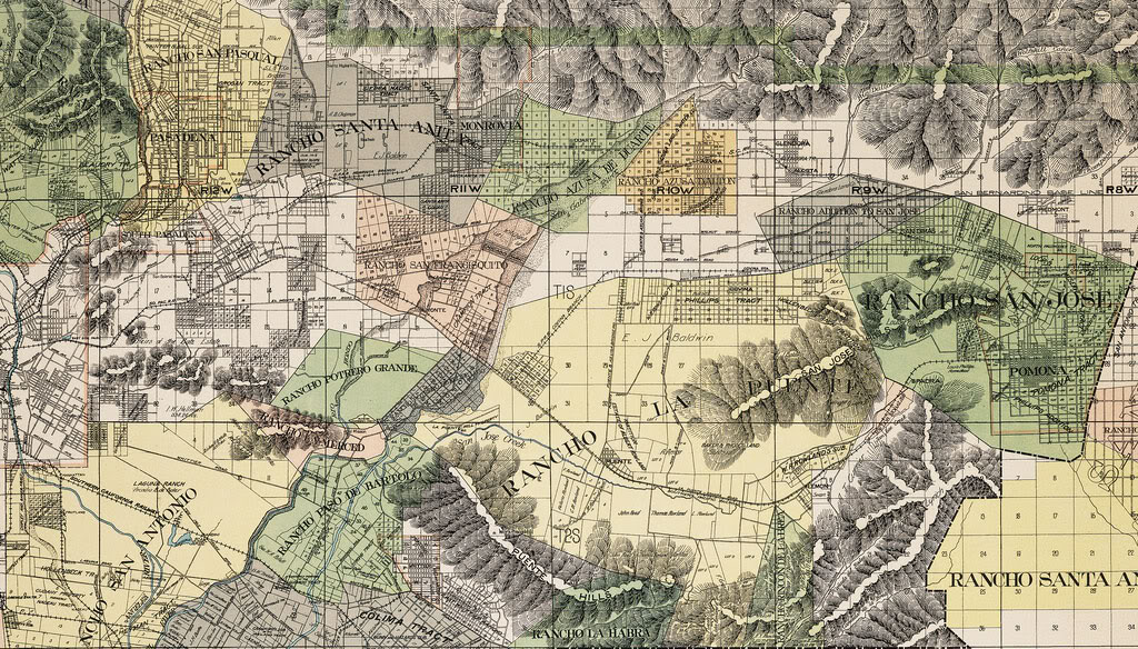
These highly-detailed maps show the boundaries of the former Spanish land grant Ranchos around Los Angeles County in 1898. Click on the link at the bottom of each map below to examine them closeup.


calisphere


Here is the section covering the San Gabriel and Walnut valleys. This one actually interests me more, personally, because this is the part of L.A. County that I grew up in.


calisphere


I hope you enjoy them. I can study these maps for literally hours on end...


Friday, November 27, 2009

Old panoramic "birds-eye" maps

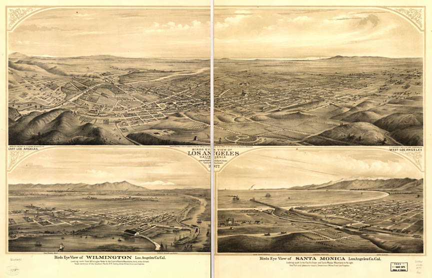
These "birds-eye" maps of old Los Angeles on the Library of Congress website are must-have resources for any serious student of L.A. history.

The 1909 map is, in my humble opinion, the Greatest Map of L.A. Ever! This is the image that I referred to in this older post that first put the hooks in me with regard to historical Los Angeles. I've practically memorized this map, I've looked at it so many times.

Viewing tip: when you click on the thumbnail image and go to the Library of Congress page, don't bother with the complicated inline viewer, just go to the lower left of each page where it says "Download JPEG2000 image," snag that file, then view it directly in your computer's default picture-viewing program.

1909:


Click image for source at the Library Of Congress.


1894:


Click image for source at the Library Of Congress.


This one is notable for the detail of the landmark buildings depicted on its margins.

1891:


Click image for source at the Library Of Congress.


This is the earliest birds-eye map of Los Angeles in the online LOC database. Note the covered bridge over the Los Angeles River at Macy Street...

1874:


Click image for source at the Library Of Congress.


Thursday, September 24, 2009

Historical map overlays at ucla.edu

[Note: the information in this post is obsolete.]

Recently, reader Gregg D'Albert wrote to tell me about the "hypercities" project at ucla.edu. This is an archive of historical maps of Los Angeles city and county that you can view in their original form, and also view as overlays on today's Google maps. Got a few minutes to explore a little? Whenever you're ready, begin by opening the URL below into a new browser tab or window:

http://linuxdev.ats.ucla.edu/#item_type=collection&item_id=8835

The site does have some limitations. For one thing, it can't be used with Internet Explorer. The interface is also a bit confusing at first. Here's how to view the maps and overlays.

First, go to the upper right of the map, and change the view from Satellite to Map. While you're up there, click the X box in the upper right of the sidebar to reveal the map selection menu.

Next, click the green button at upper left. Then, browse the available maps in the sidebar. Mouseovers of each menu item show the area covered by that map.

My favorite one to start out with is the 1898 "Official Map of the County of Los Angeles California." Click on that item in the sidebar, then wait for the map to load at left. (This can take awhile if you have slow DSL like I do.)

Now notice that there is a slide control inside the map's sidebar item. Move that back and forth to adjust the transparency of the historical level.

With the 1898 map, though, I recommend first just inspecting it as is for awhile. Zoom in there for a close look (remember to be patient as the historical map loads). The details are really fascinating! Find where you live now and see it as it was just over 100 years ago, and be amazed at the changes that have occurred here in the span of only 1-1/2 lifetimes...

Another one that's fun to explore is the 1897 Maxwell's City Directory street map. See Wilshire Boulevard when it was only 4 blocks long!


From 1897: The new Wilshire Boulevard at upper center (ats.ucla.edu).


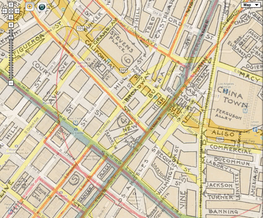
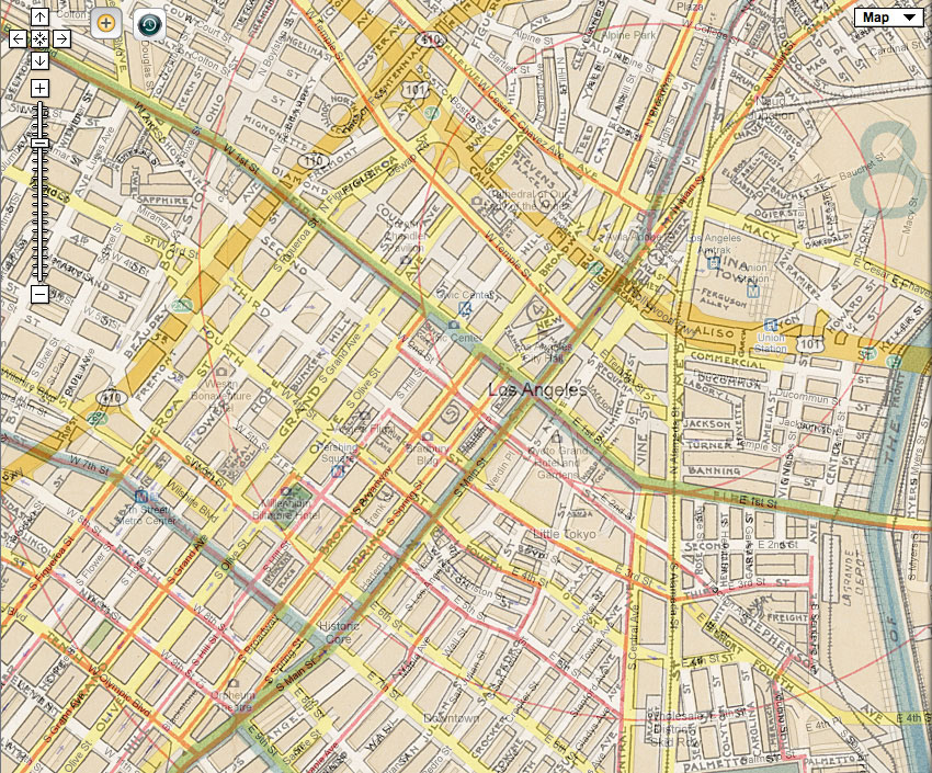
Here, also, are two much better overlay "then and now" maps of the streets of Downtown than I presented in this post.


I hope the folks at ats.ucla.edu won't mind me reproducing this small portion of its wealth of old maps! That hypercities site really is quite addictive, I must say.


Friday, August 14, 2009

Whose palms are these, anyway?

Seems I've uncovered a bit of a mystery. Here, previously, I've told the story of "General Longstreet's palms." In it, I related information I found on the USC Digital Library site which stated that the palms and the house pictured in these two photos were on property owned by Confederate General James Longstreet, most notably of the Battle of Gettysburg fame.


Trouble is, subsequently, I have never been able to independently corroborate that James Longstreet ever lived in Los Angeles, or that he even owned property there. No biography of the man that I've been able to find thus far has him setting foot in California during his entire life.

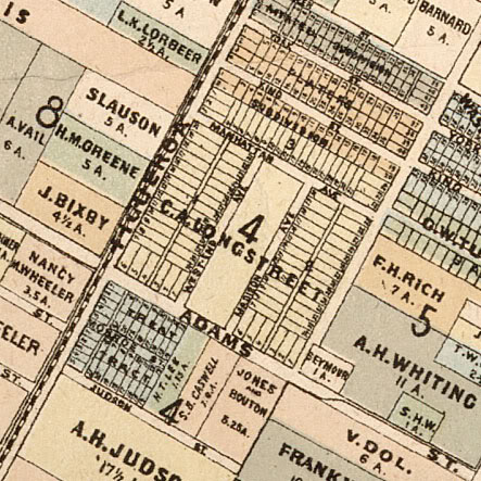
Then, the other day, thanks to reader Gregg D'Albert, I got pointed to the hypercities site, and there I found an 1884 map of Los Angeles showing the ownership of plots of land in the old city. Of course, the first thing I did was go to Figueroa and Adams to see who owned the Longstreet palms.


Well, as you can see, the tract in question was, indeed, owned by a Longstreet, but it was "C.A. Longstreet," not "J. Longstreet." Puzzling. Then I thought, wait, there was that 1938 Nuestro Pueblo article about the palms that also referred to a General Longstreet. Surprise! I'd missed the fact previously that that article referred to a Gen. Joseph Longstreet, not James Longstreet. Also, this Joseph Longstreet's wife was named Lucy, not Louise, and Lucy had died in 1917, versus 1890 for the CSA General's wife.

So, who then was General Joseph Longstreet, and how was "C.A. Longstreet" related to him? I've tried finding info about the other Longstreet on the web, but my search has gone nowhere yet.

Whatever Gen. Longstreet planted those palms, though, they still remain historically significant as possibly the oldest living things in Los Angeles. It would have been nice to be able to connect them with the famous General Longstreet, but even a not-so-famous General Longstreet will do just as nicely, too. ^^

Read the next installment in the saga of the Longstreet Palms: 'Year of the palm?'


Tuesday, May 19, 2009

L.A. Streets: Then and Now

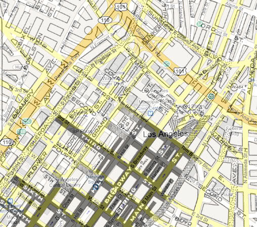
Back when I was first learning about Los Angeles past, I made frequent use of Brent Dickerson's wonderful illustrated historical narrative, A Visit to Old Los Angeles and Environs. (I continue to learn a lot from it to this day, in fact.) Anyway, in his page about New High Street and Broadway, Mr. Dickerson presents a map of the street layout in downtown in the early 20th century. I've found it to be very useful a number of times, especially for finding streets that no longer exist.

A few months ago, though, I got the idea to superimpose a Google map from today over the old map, mostly to see exactly where the freeways were built in relation to the existing streets and neighborhoods of the '40s and '50s. Here was the result:


Unfortunately, I couldn't get the two maps to align precisely, but this was a good enough result for the purpose I intended, and much more. I hope you find the many possible comparisons as interesting as I do!

(Thanks to Mr. Dickerson for permission to post the modification of his original map.)

ADDENDUM: There are two much better overlay maps in this post. Check those out, if you haven't already.


Saturday, May 2, 2009

The Spring Street diagonal

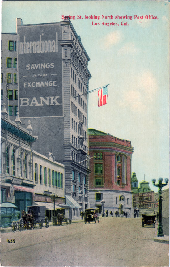
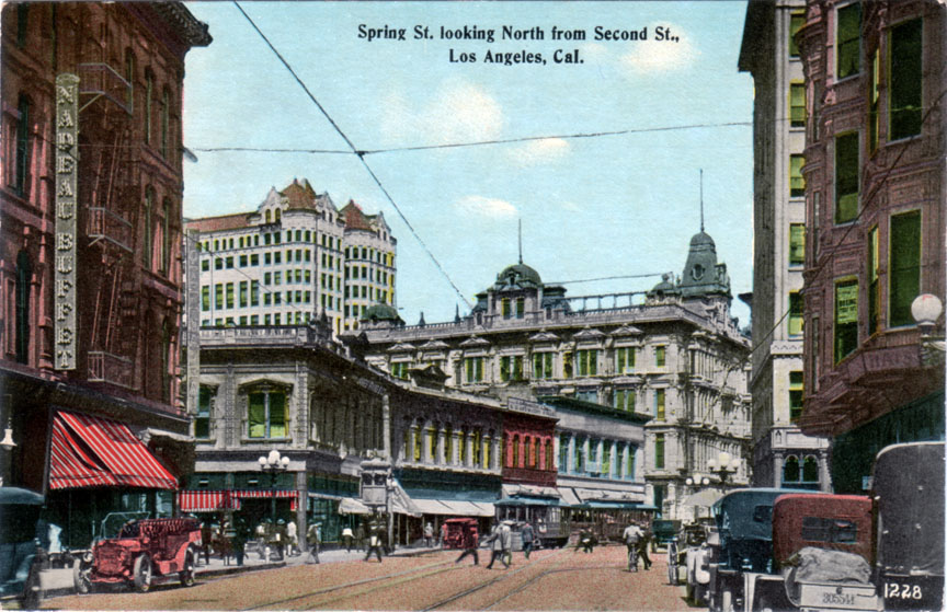
Ever since I started collecting postcards of old Los Angeles, this 90-year-old view of the north end of Spring Street has been one of my "holy grails." One reason for its desirability is that it features the old Post Office that first got me interested in pre-WWII Los Angeles. Mostly, though, this card fascinates me because this particular stretch of Spring Street no longer exists at all.


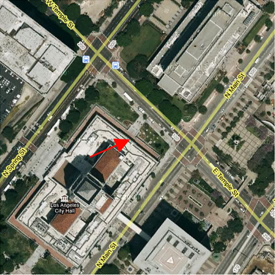
In fact, this portion of Spring's not only completely vanished, this exact vantage point is today located inside L.A.'s City Hall! (See position of red arrow below.)


Google Earth.


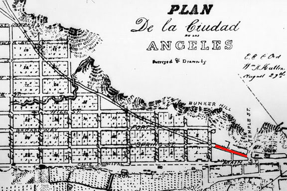
Here's the backstory. Before 1927, when work on the new City Hall began, Spring Street north of First Street did not run parallel to Main Street and Broadway as it does today. Rather, north of First, Spring jogged east-northeasterly, following a diagonal course to the intersection of Main and Temple (the postcard view). This short diagonal portion (also in red, below) was actually the last vestige of an old indian footpath along the base of Bunker Hill which pre-dated the establishment of the Mexican pueblo itself.


Detail from the 1849 Ord survey map.


Here are a couple of other postcard views of Spring Street as it was before 1927. This first one shows the intersection of Spring and First Streets, looking north, around 1915. You can see that Spring continues straight through past the intersection for about 30 or 40 feet, then it turns at an angle to the right. That's the beginning of the old diagonal alignment.


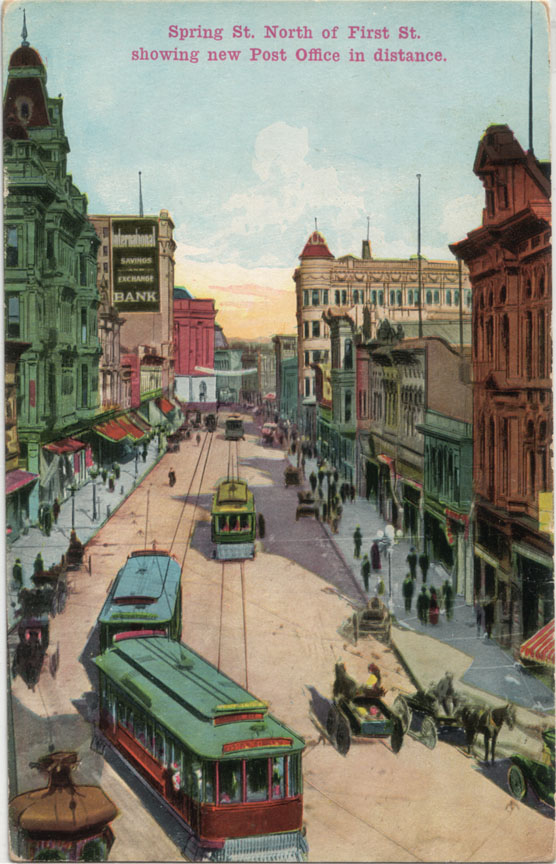
Now, if we were to go up on the roof of the building at the NW corner of Spring and First and look further up the street, this is what we'd see.


And there, near the end of Spring, is that International Savings and Exchange Bank building again, and the 1910 Post Office just beyond that.

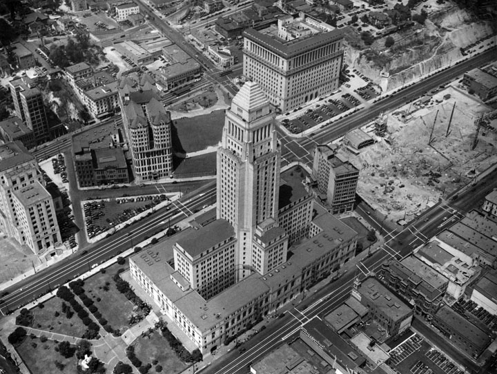
A later perspective: here's a photo of the Civic Center in 1938, after Spring Street had been straightened. That structure just to the immediate right of City Hall is the same International Savings and Exchange Bank. Note the angle of the facade. That was the last visible evidence of the old diagonal alignment of Spring Street...


gsjansen on Flickr.


Thursday, September 25, 2008

"Best lighted Street in the World."

While on the subject of street lighting, I'd like to share what is probably my favorite postcard of old Los Angeles: this view of Broadway from First Street. Note the caption. Broadway is said to be the "Best lighted Street in the World." Although the card was mailed in 1907, I believe the image itself may be about a decade older, from around the turn of the last century (due to the conspicuous absence of automobiles).


I love this card mostly because the detail in it is amazing – it really brings the old city alive for me. Broadway was both the commercial center of Los Angeles and the seat of its government. (The tall Romanesque campanile with the pyramidal top is the bell tower of the old City Hall, built in 1888 – at that time, the tallest structure in Los Angeles.) Sadly, as with my even older postcard of Spring Street, not a single structure visible on this Broadway postcard remains standing today.

Here is the same view today. What was once a bustling downtown street filled with people, commerce and civil life is now a home only for sterile monolithic buildings.


View Larger Map


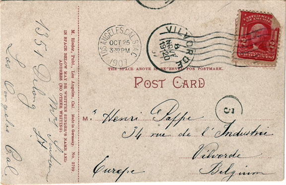
The postcard itself has an interesting story to tell. It was originally mailed to Belgium, and as you can see, it took almost a month to get there; traveling as it must have by sea.


In Europe, the postcard somehow survived two World Wars, made its way to the Netherlands where I bought it from an eBay seller there, and in the 21st century, the postcard is now back in California, with me. ^^

Now, see where the person who sent the card lived, and what's there today...

I can't quite decipher the name of the sender. It looks something like "Mrs. Linton," but her address is clearly "1351 Delong St."; note her 1s written in the European style.

Well, Delong Street is another of those vanished residential L.A. streets, like Palm Drive. And actually, Delong turns out to be walking distance from Palm Drive, in what was generally a very nice old out-of-the-way part of town.


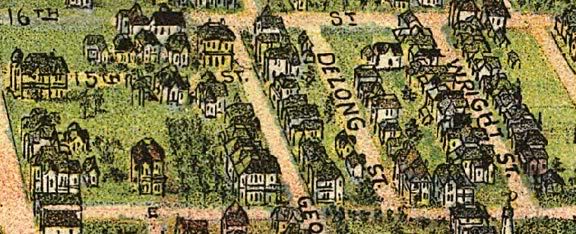
Here's a view of Delong from an 1894 "bird's eye" map of Los Angeles.


We're looking towards the south here. In L.A., odd numbered addresses are on the west sides of streets, so 1351 would probably be the house immediately to the right of the "S" in "ST.", or maybe the small green one up and to the right of the "S."

Anyway, here's an aerial view of the neighborhood today, and a Google Maps Street View image. Delong Street is now occupied by the Los Angeles Convention Center...


Google Earth.


View Larger Map

Where «34 rue de l'industrie» is in Vilvorde, Belgium, though, I wasn't able to determine. Like Delong St. in Los Angeles, it, too, is likely no more...


Sunday, July 20, 2008

The Longstreet Palms: The oldest trees in Los Angeles?

EDIT (10/2/2021): Please note that this article contains many statements which, through subsequent research, I discovered are factually incorrect, especially the alleged connection to Confederate General James Longstreet. Click on the "longstreet palms" tag here or at the bottom of the page to read the most recent and accurate findings on this very interesting subject!

It's funny how things that we don't pay any attention to at first can gradually worm their way into our consciousness and eventually become an obsession.

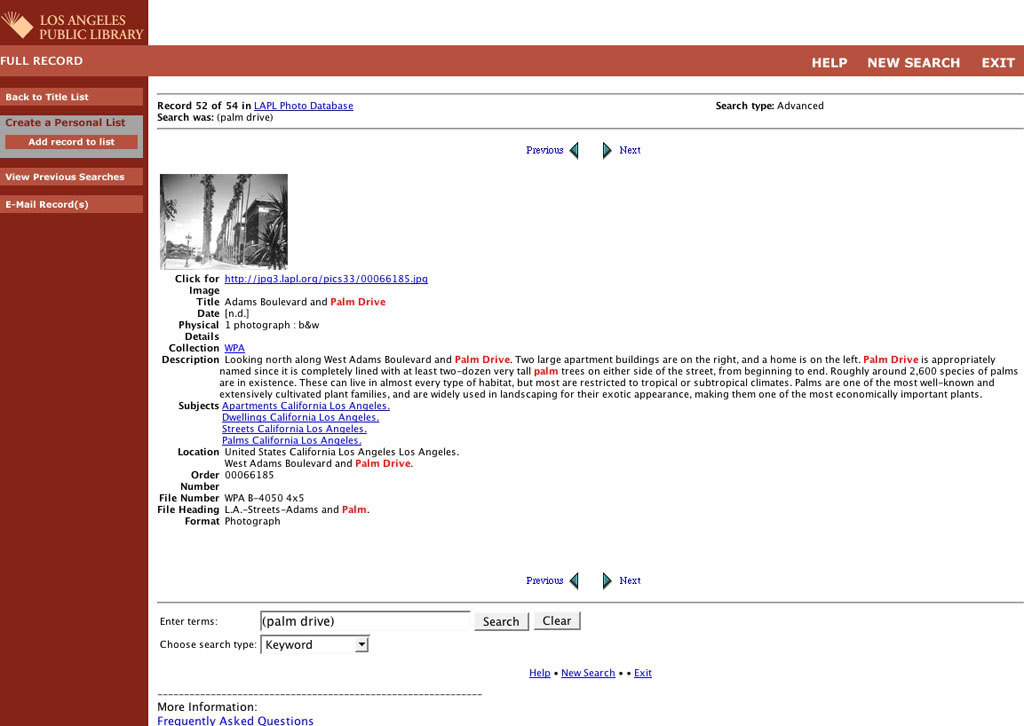
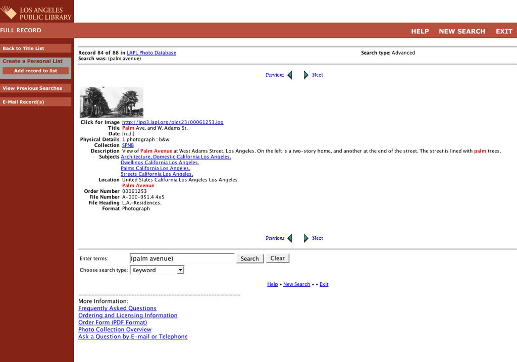
Here's how one such obsession of mine began. As you can tell from my blog, one of my hobbies is collecting postcards of old Los Angeles; a common subject of which is a "palm drive" or "palm avenue," depicting a street lined usually on both sides with either native or exotic palm trees. Stereotypical California scenes, I thought, of no real noteworthiness. So, I generally ignored these palm-themed postcards – my specialty is downtown street scenes and buildings – but after a while, I started to notice that a lot of the really old palm postcards appeared to depict one specific location: one on or near West Adams Street.
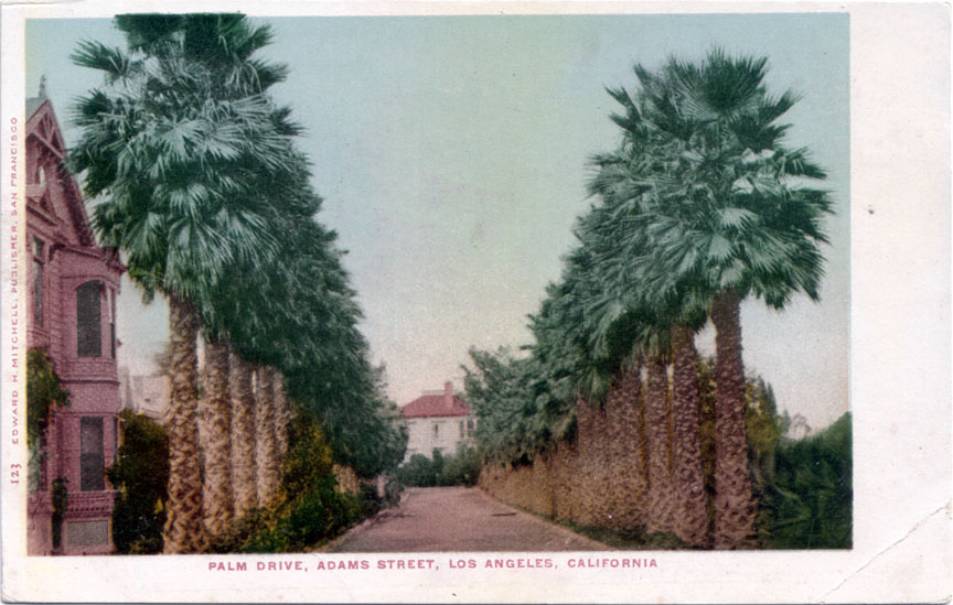


Curious, I looked it up in my 1941 "Hill's Guide" of Los Angeles, and was somewhat surprised to learn that Palm Drive was an actual place.
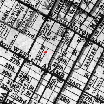


Then, I went to Google Maps to check the location today. I recognized the area immediately. It's an old memory from my childhood, actually. Palm Drive is located on what is now (or was) the campus of the world-renowned Orthopaedic Hospital. I almost stopped my search for the palms at that point, thinking it unlikely they'd still be there. But just on a whim, I decided to have a look at the location with Street View. What I found simply blew me away. Amazingly, the palms still lived!


View Larger Map


Look how tall they are! Given that the early postcards of these palms were from the first decade of the 20th century, this meant they were at least a full century old. Truly remarkable! What I was about to find out, though, is that these palms were, in fact, much older, and even more remarkably, they had an improbable connection to a well-known figure in American history...



Cutting to the chase: in the course of my research, I uncovered convincing evidence that these two rows of Washingtonia fan palms could very well be the oldest living things in Los Angeles. They were planted by none other than Confederate General James Longstreet, about 135 years ago. That may not sound terribly ancient, but to better frame the time perspective, there are only 4 man-made structures still standing in all of Los Angeles that are older than these palm trees.

I compiled the following pictoral history principally by piecing together photos and bits of information I gleaned from two online archives: the USC Libraries Digital Archive, and the photographic collection of the Los Angeles Public Library. Now, watch the palms grow through the years!

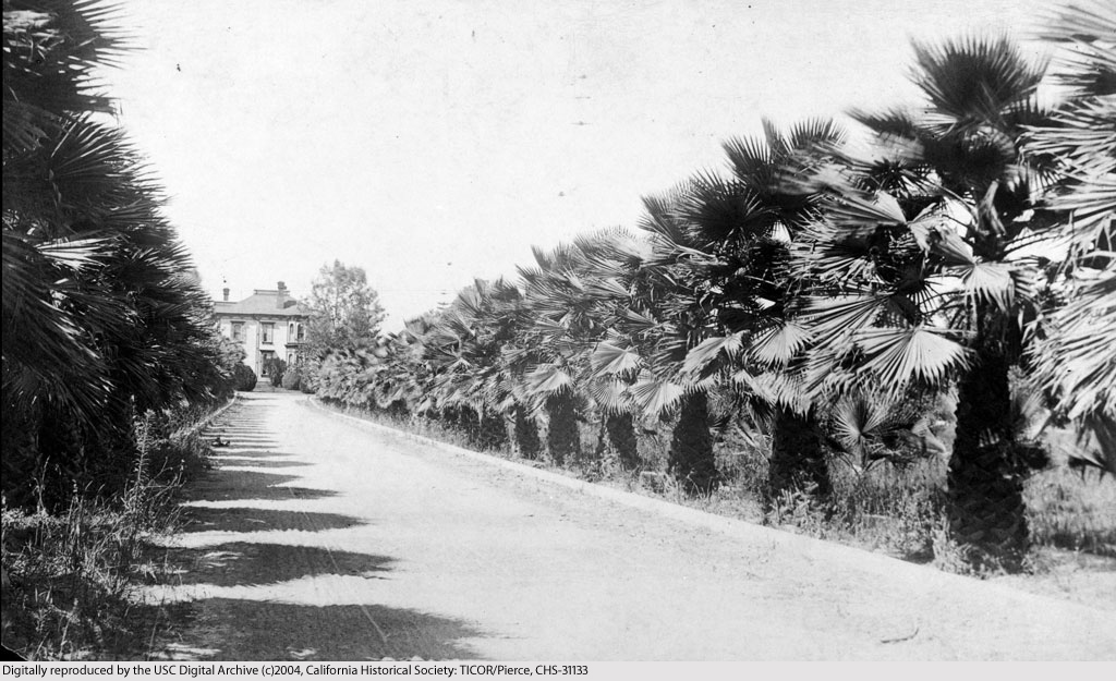
c.1875: This is the earliest photo of Palm Drive that I've been able to find. ("Early" defined in terms of the height of the trees themselves.) How old are they here, really? There's a house near mine that was built around 1992 that has a Washingtonia in its front yard that is about as tall as these are below. From that, I infer that these historic palms probably began life around 1860. That would make them almost 150 years old  today. It was from the text accompanying this photo that I learned about the connection to Gen. Longstreet (that's his home at the end of Palm Drive).

Courtesy U.S.C. Digital Library.


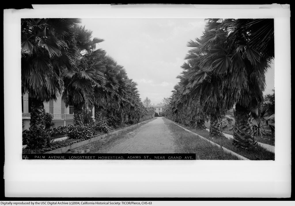
1886: More information about Longstreet and his estate: "From a letter to the Herald Express (1940 February 5): 'About 1875, Confederate General Longstreet acquired the 40 acres on the northeast corner of Figueroa and West Adams streets. He did what was possibly up to that time the most extensive grading job done in Los Angeles. He made a pleasing slope up to where the house was to be built, a slope such as we used to read about in southern love stories. He built a mansion of Southern grandeaur [sic] and elegance and made the entrance from West Adams, between the palms which he planted, a southern romance. He planted the whole place with orange trees and it became the showplace of Southern California...'."

Courtesy U.S.C. Digital Library.


c.1900: This scene looks very similar to the photos of Palm Drive in the earliest 20th century postcards (e.g., as above), so even though this photo is undated, around 1900 seems about right. Here is a photo of General Longstreet's estate's grounds taken around 1890-1900. The caption mentions that the house at this time "was in use as an osteopathic hospital." The website for Orthopaedic Hospital says the clinic was founded in 1911, but evidently the property's history as a place for treating bone disorders extends back in time to the late 19th century when the property was still owned by Gen. Longstreet himself.
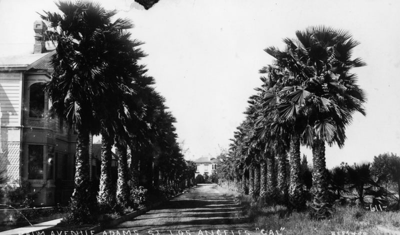

Courtesy Los Angeles Public Library.


c.1910: The referenced page says this photo was taken around 1920, but I guesstimate it was more likely taken closer to 1910.
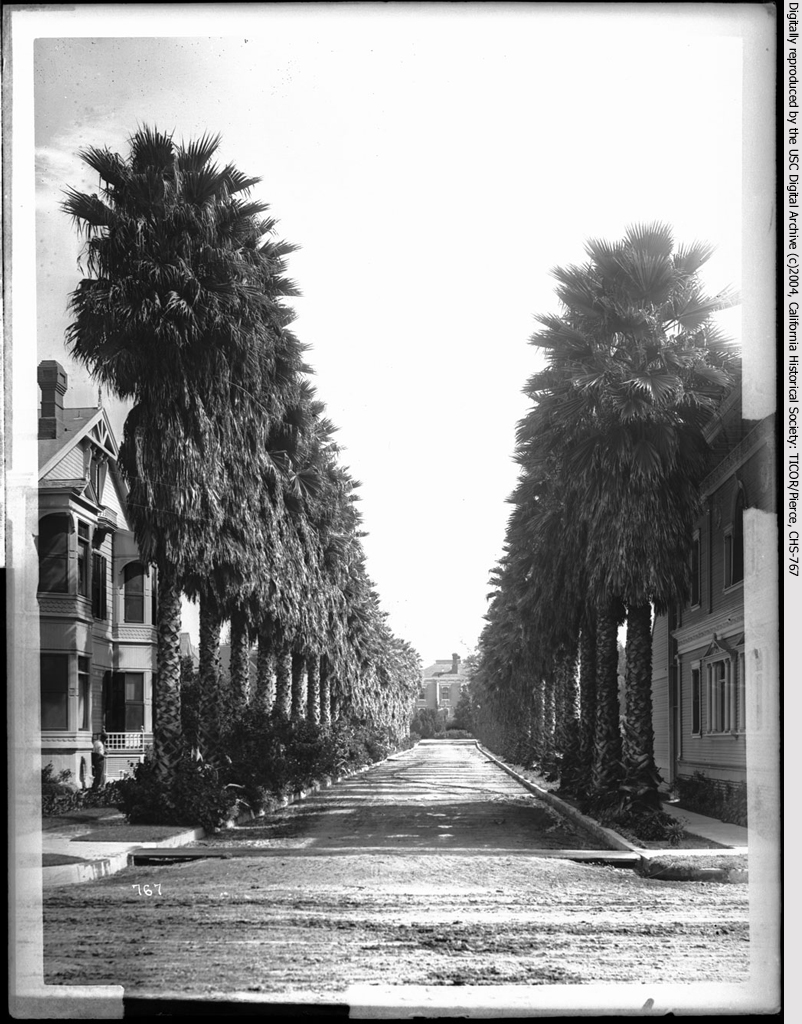

Courtesy U.S.C. Digital Library.


c.1920: The text accompanying this photo gives the account that, at the time, these were the "tallest palm[s] in the city." Aha! Logically, if these were the tallest, then they were also likely the oldest. The more famous palm-lined avenues of Beverly Hills were just being planted in the late 'teens/early '20s. The trees of Palm Drive were already about 60 years old by then.
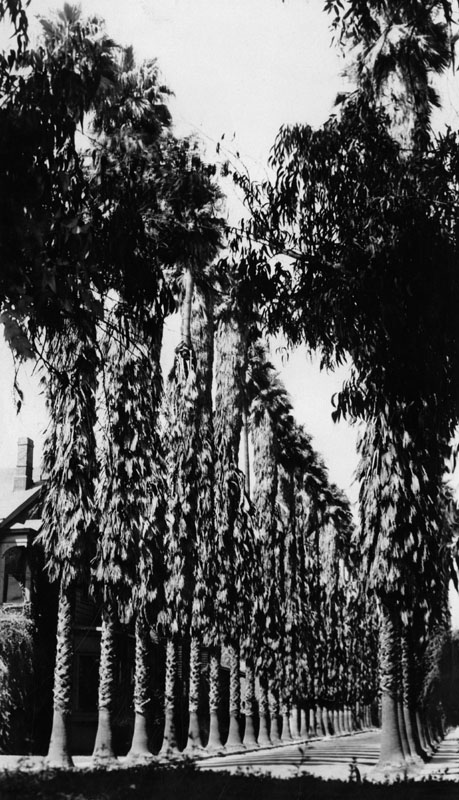

Courtesy Los Angeles Public Library.


c.1928: From the back cover of "La Reina - Los Angeles in Three Centuries," published by Security Trust & Savings Bank, 1929. The palms are truly in their prime! General Longstreet's house is gone now, and at right is the Holton Arms, an upscale West Adams "apartment hotel."
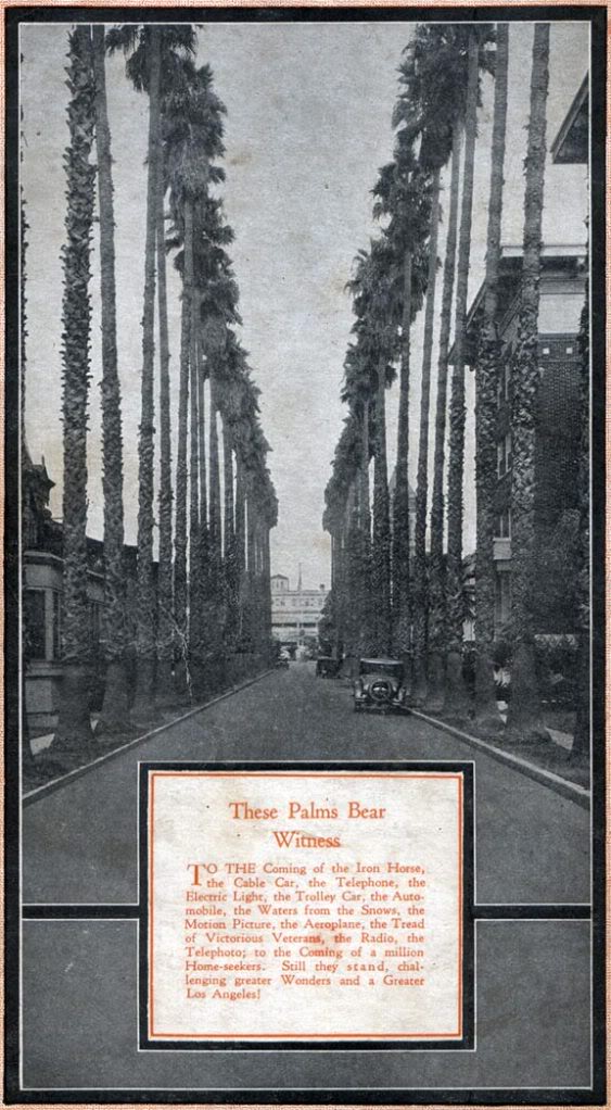


c.1940: This is the latest photo I was able find of the historical palms in the online archives. By this time, even before WWII, they had been here for 65 years, and were approximately 80 years old...
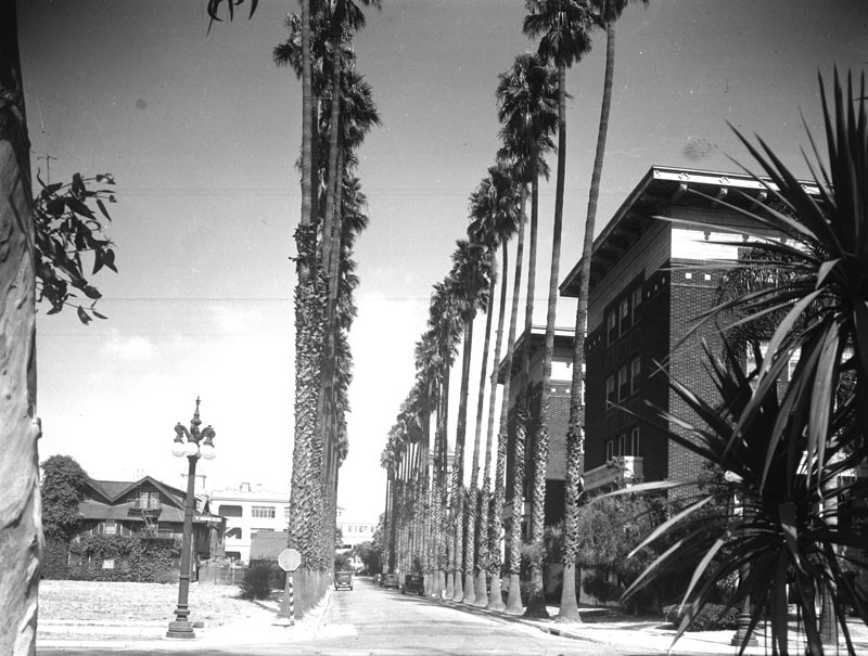

Courtesy Los Angeles Public Library.


And it just so happened that while I was beginning to put the finishing touches on my information search, one of my favorite L.A. blogs (Larry Harnisch's The Daily Mirror) reprinted a column about General Longstreet's palm trees that had appeared in the Los Angeles Times 70 years ago, on July 8, 1938:
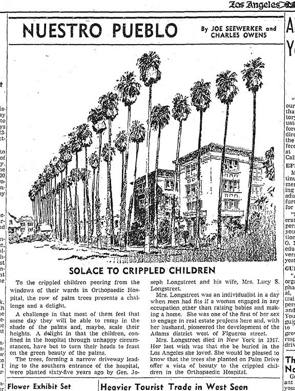


Click image for source.


Reading this old "Nuestro Pueblo" article was a big thrill, as it provided independent confirmation of many of the factoids I'd found in the USC and LAPL archives, with the happy inclusion of Mrs. Lucy Longstreet's role in the story.


On to the present day... via the web, I've learned that the site of Orthopaedic Hospital was sold in 2006, and that its redevelopment for luxury apartments commenced in 2007. According to this page, it appears at least some of the ancient palms have already been removed; perhaps all of them are gone now, I don't know. I don't live in the L.A. area, or I would definitely look into this myself.

It would truly be a shame to lose these venerable survivors. I wonder if anyone else but me has any idea just how old or significant these palms really are – that they were planted by a famous Confederate General and his wife, that they were once a celebrated showpiece of Los Angeles, and that today, they might just be the oldest living things in the entire city. Are Gen. Longstreet's palms really gone? I sincerely hope not...

Read the next installment in the saga of the Longstreet Palms: 'Whose palms are these, anyway?'
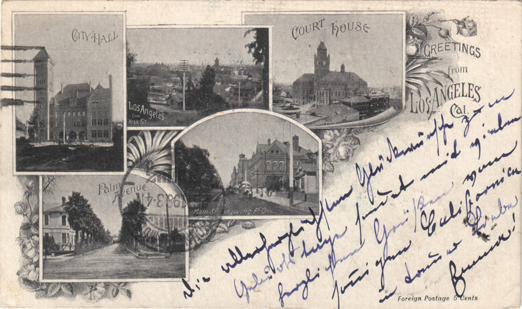


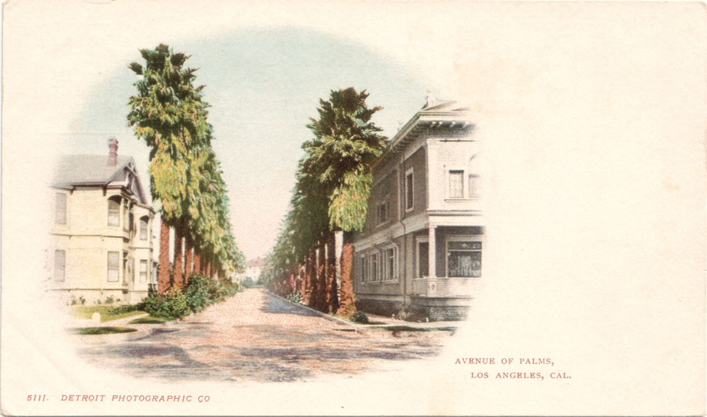
An 1899 postcard featuring "Palm Avenue."