A vanished city lives again...

Showing posts with label panoramas. Show all posts

Friday, May 2, 2014

Little House on Pearl Street

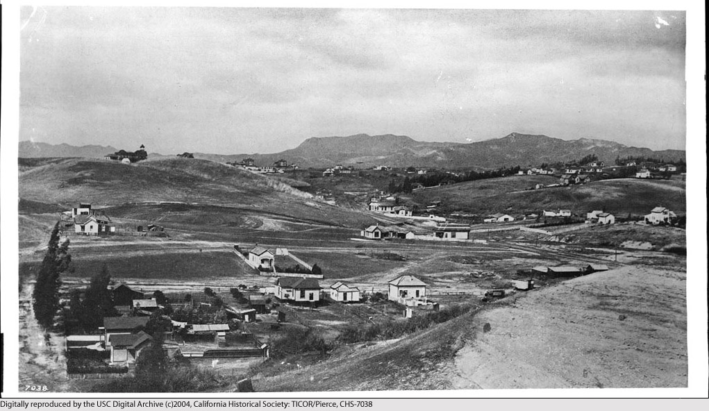
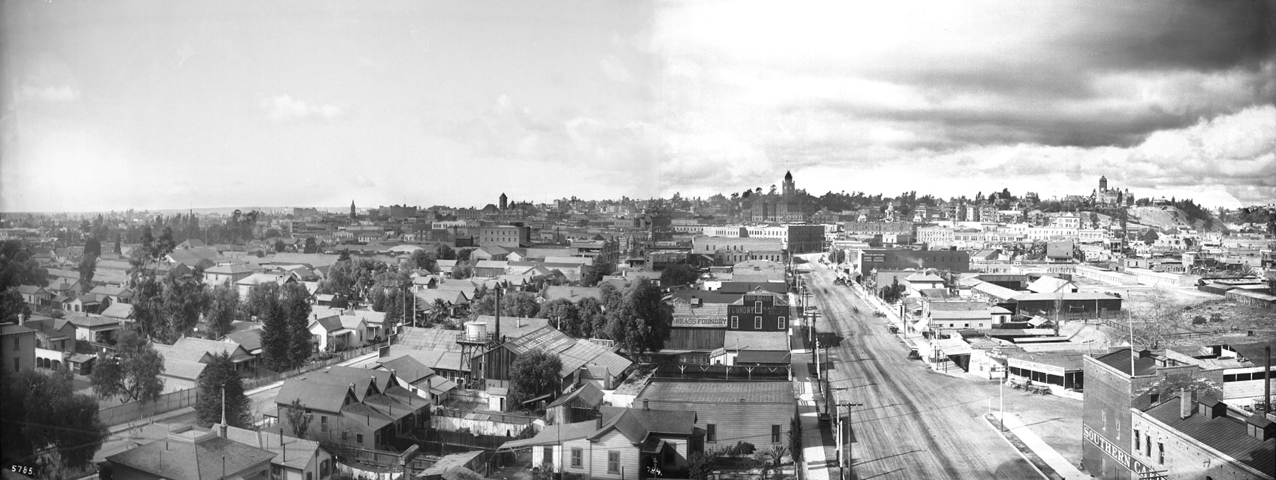
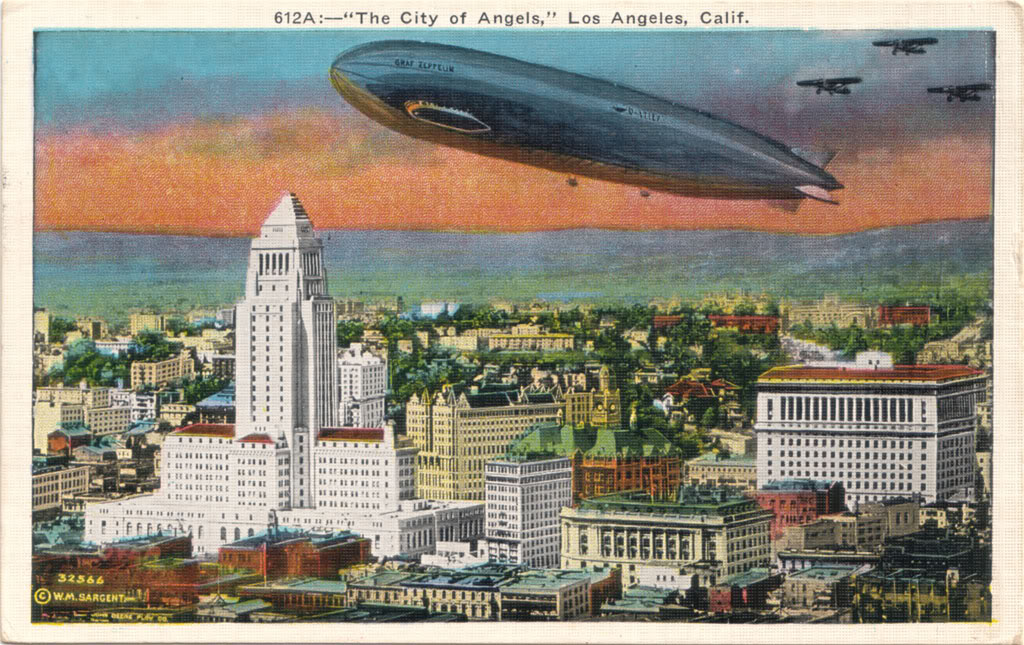
This is Los Angeles, almost exactly a century ago. Doesn't look very familiar, does it? That's because, with the exception of a few homes in the hills in the far distance, every single structure you see in this photo is now vanished off the face of the earth.


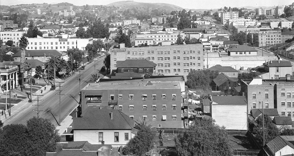
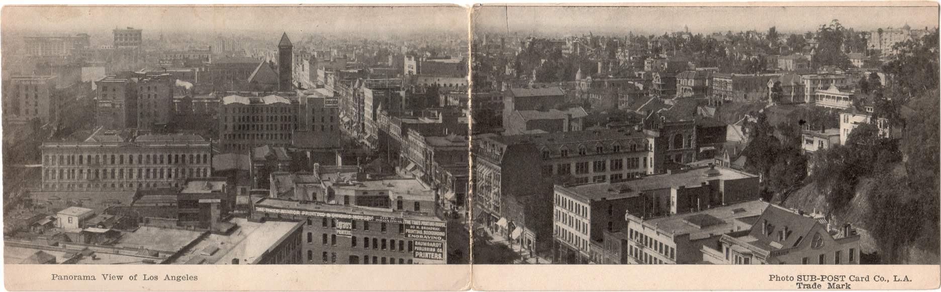
"Panoramic view of Los Angeles, showing Sixth Street, Figueroa Street, Flower Street, east side of Sixth Street, ca.1916" (detail), C.C. Pierce, photographer. Courtesy USC Digital Library/California Historical Society. Link to full-res image.

When the picture was taken in 1916, this area was called the Apartment District. Today, it's the heart of the Financial District. The street to the left is Figueroa (formerly Pearl), and that's its intersection with Fifth Street at left. From 1928-1968, to our immediate right and just in back of us here, the late, lamented Richfield Building once stood. Now, the twin towers of City National Plaza would be directly in front of us, and past the Streicher Apartments, that entire city block is now occupied by the Westin Bonaventure Hotel. From the left edge of this picture into the hills to the north, the Harbor Freeway (I-110) now cuts a wide swath through this old residential neighborhood, and atop the hill at far upper right (if we could see through the buildings in front of us, that is), we would be able to catch a glimpse of the top of the Walt Disney Concert Hall, and the Dorothy Chandler Pavilion just beyond.


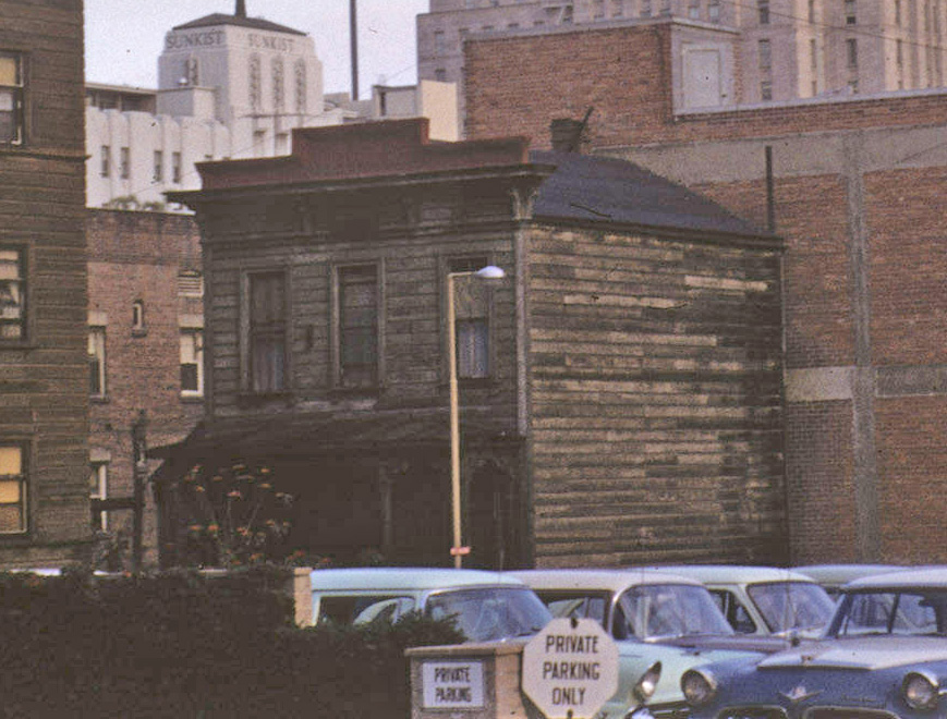
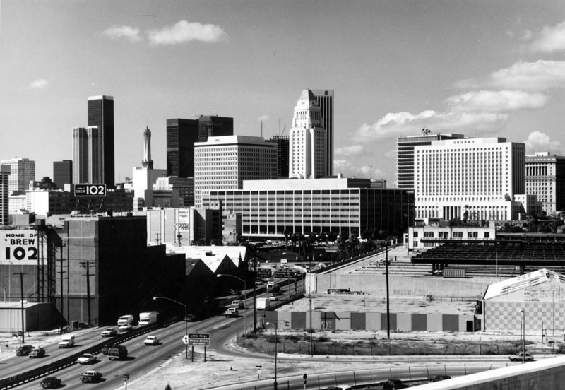
But this post isn't about any of these grand modern buildings. It's about the oldest structure you see in the photo above that was still standing in 1957 when the photo below was taken. See that rather forlorn-looking little wooden house in the rear of the parking lot?


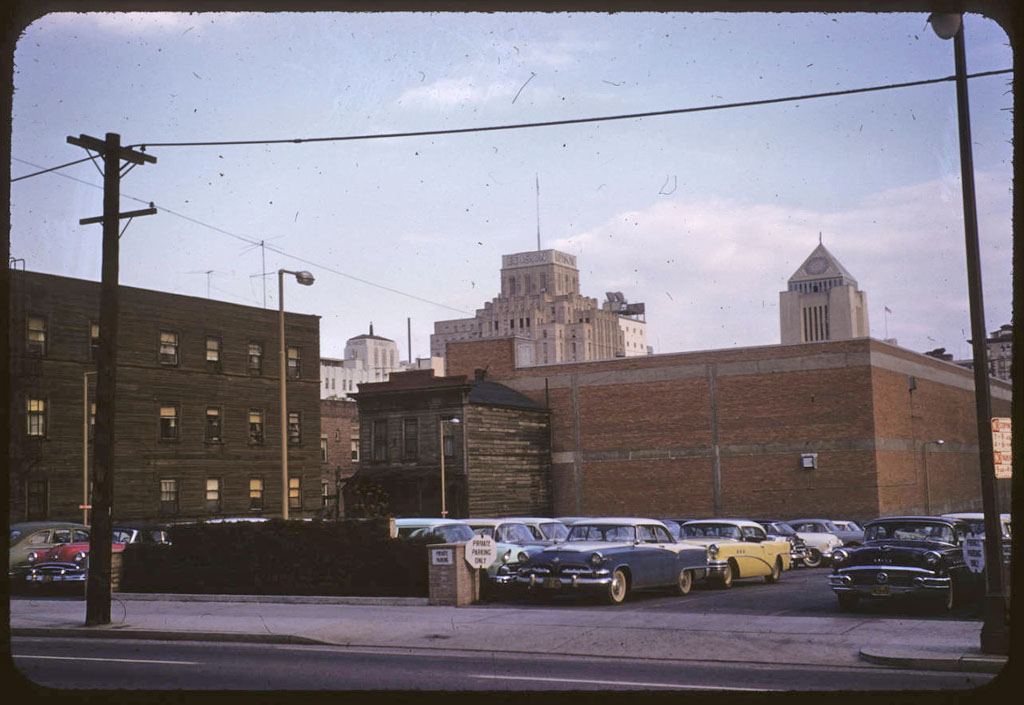
"Oldest building in downtown Los Angeles," Palmer Connor, photographer. From the Palmer Connor Collection of Color Slides of Los Angeles. Courtesy of The Huntington Library, San Marino, CA. Link to full-res image.

That's the exact same building with the square white side that's in the right foreground of the picture at top. Although some architectural elements of the house suggest it might be from the 1870s, the structure actually makes its first appearance on a Sanborn fire insurance map in Volume 3 of the 1894 edition (it was not present in the 1888 edition). Its original address was 516 Pearl Street. When the St. Dunston Hotel was built on that property not long after the turn of the last century, though, the little house was moved to the rear of the lot and became 516-1/2 Figueroa. It was this move back from the street frontage that probably saved it from the wreckers for as long as it was.

Quite amazing to think that, in 1957, the "oldest building in downtown Los Angeles" had only been standing for about 65 years. And yet, 60-70 years was pretty much the maximum life span of any 19th century building in the old city. Los Angeles, impermanence is thy name...

(For more on this story, click here.)


Friday, February 14, 2014

View from atop Crown Hill, c.1886

This has to be one of the more remarkable images of historical Los Angeles that I have ever seen. The year is around 1886, and we're looking south toward what would become Long Beach from the present site of Belmont High School, near the intersection of Beverly Blvd. and Glendale Blvd. In the far distance at right is the still-recognizable profile of the Palos Verdes peninsula, at left, the Santa Margarita Mountains by San Clemente, and in between, what today is solid cityscape was then nothing but sparsely-settled open rangeland as far as the eye could see.


Click image to enlarge.


The photo was taken from the roof of the Belmont Hotel, which was located atop Crown Hill at the end of the old Second Street Cable Car line.


Courtesy U.S.C. Digital Library, California Historical Society.


The contemporaneous photo below shows the Belmont Hotel (upper left) as seen from Bunker Hill. The vantage point is near what would later become Hope Street overlooking Third Street (the road at the extreme left edge of the photo is Third). Today, the Harbor Freeway (I-110) runs left/right directly through this little valley. The familiar hills overlooking Hollywood can be seen in the distance.


Courtesy U.S.C. Digital Library, California Historical Society.


To learn more about the historic Belmont Hotel, click here.


Saturday, November 24, 2012

1891 Landmarks

Apologies for the hiatus. Seemingly endless computer snafus and trainwrecks in my personal life have kept me from spending more time indulging in my favorite avocation. Anyway, recently, I used Photoshop to do a little color mod of this panoramic map of Los Angeles from 1891. The highly-foxed original image cleaned up rather well, I think!

Before:

Library of Congress.


After:

Library of Congress.


The buildings depicted in the margins are worth a much closer look.


Library of Congress.


Library of Congress.


8 more behind the jump!

Friday, September 14, 2012

Panorama of Los Angeles, 1899


Click image for full-size enlargement. Images courtesy U.S.C. Digital Library.

A panoramic view of Los Angeles in 1899, looking west from atop the Maier & Zobelein Brewery, known to later generations of Angelenos as the "Brew 102 building." The four tall structures visible here were, from left to right, the Cathedral of St. Vibiana, City Hall, the County Court House, and Los Angeles High School.

In the entire panorama above, I can make out only six buildings that are still standing today.

The broad boulevard was Aliso Street. Today, it is U.S. Highway 101. The old Brew 102 building and the modern freeway can be seen in the photo below, circa 1976.


Photo by William Reagh, courtesy Los Angeles Public Library Photo Collection.


Friday, August 12, 2011

Civic Center panorama, 1946

The Los Angeles Civic Center, viewed from Broadway, March 11, 1946.


Source: Library of Congress.


Link to full-resolution TIFF file at loc.gov (4.6 MB).


Tuesday, June 7, 2011

1929 Postcard


I've wanted this particular postcard for a long time, and now I finally have one of my own. The coloring is way off, but the aerial perspective of the Civic Center in 1929 is great. What's most striking to me isn't the Graf Zeppelin; it's that City Hall (left) and the Hall of Justice (far right) are the ONLY two buildings in this entire view that are still standing today. Everything else – every structure, tree, even the hill just beyond the Civic Center – is gone off the face of the earth. And this is Progress!


Monday, January 31, 2011

View from atop Angels Flight, 100 years ago

A panoramic postcard view of Downtown Los Angeles from atop the observation deck of Angels Flight, just over 100 years ago.


Click image for a nice 2592x503 enlargement.


I believe this photo can be dated fairly precisely to late summer 1910, as the second Los Angeles Times Building has not yet been bombed, and the Hall Of Records behind it is in the earliest stage of its construction. Quite a remarkable view, in my layman's opinion!


Thursday, December 9, 2010

1904 panorama

Recently obtained: this "double postcard" panoramic view of Downtown, as it appeared near the turn of the last century. The diagonal street at center is Broadway, and we're looking roughly south from atop the clock tower of the old County Court House at Temple Street. To the left is Spring Street with its intersection with First Street, and to the right is the still largely intact residential area of Bunker Hill.

Today, looking to the right, the same view is pretty much solid skyscrapers.


Click image for a nice 1872x582 enlargement.

The postcard is undated, but my best guess is that the photo was taken in 1904. The Hotel Lankershim at the far end of Broadway opened in 1905, but here, the building appears still to be in the later stages of its construction.

Is there any way a normal person living here today would recognize this as Los Angeles? Amazing that a cityscape could change so completely in only one-and-a-half human lifespans, isn't it!


Thursday, March 18, 2010

Bunker Hill panorama: Then & Now

Bunker Hill, viewed in its entirety, as few people alive today have ever seen it.

c.1939:


Source: USC Digital Library. (Record IDs: whit-m2777, whit-m2775, whit-m2776 & whit-m2779.)
Click on image above to enlarge.


Only one human lifespan later, the same vista is virtually unrecognizable.

2009:


Photo by J Scott Shannon.
Click on image above to enlarge.


Friday, February 12, 2010

South Broadway, 1905-'06

Recall the image from my last post, which was taken from the roof of the then-new Hotel Lankershim. Now, turn 90 degrees to your right, and this is what you would see. It's South Broadway, looking north from Seventh Street, in winter 1905-'06 :


Source: USC Digital Library.


A pleasing vista of the old city, isn't it? There are familiar landmarks like the pyramid-topped tower of City Hall up the street, with the Los Angeles County Court House on the hill in the background. At right is the tallest structure in town: The Braly Building, or the Union Trust Building as it was called at that particular time.

I have to laugh at the sign on the also-new Hotel Alexandria at center right. "THIS FIRE PROOF HOTEL IS ABSOLUTELY FIRE PROOF." Sounds like a paraphrasing of a familiar internet meme. ;)

Pop quiz! How could I date this photo so precisely to 1906? Hint: it has to do with the conspicuous absence of two formerly-prominent (and pre-eminent) buildings at the left of this picture. If you know which buildings I'm talking about, then you know it's 1906, too! As far as it being winter – that's a very wintry view of the San Gabriel Mountains there. Looks like it does after a cold front's passed through, if my recollection of the area's seasonal weather features is correct.

As nice as this image is, I've saved the best for last. The next view I'll share with you will take your breath away, I guarantee!


Tuesday, February 2, 2010

Where the skyscrapers rise today

I realize I've been remiss in my duty here of late – not posting as much as I should (nor as much as I want). To make amends, I'm going to try to make up for my lack of quantity lately with an emphasis on quality. For starters, here's a view of old L.A. that I'll wager you've not seen before...


Source: USC Digital Library.


It's winter 1905-'06, and we're looking northwest from atop the old Hotel Lankershim at Broadway and Seventh, with Seventh Street stretching out to the hills at left. The vista shows what was called the "Apartment District" at the time. Within 25 years, frontage on Seventh would become some of the most valuable urban real estate in the West. And a quarter century after that, the area to the right of center would become the skyscraper district.

It's really something to see this area as an ordinary residential neighborhood, isn't it? Remarkable that essentially everything we see here was wiped clean off the face of the earth without a trace. No earthquake or fire or other natural disaster could have accomplished such a thorough obliteration as was wrought here by the hand of man himself...

Stay tuned! There's another even more remarkable image to follow soon.


Friday, December 4, 2009

The Melrose

One of my favorite Bunker Hill landmarks was the old Hotel Melrose (1882-1957).

138 South Grand Avenue, ?1946.


Courtesy USC Digital Library-California Historical Society.


The Melrose and its next-door neighbor, the Hotel Richelieu.


Courtesy Los Angeles Public Library Photo Collection.


The original and the "new" Melrose (at left).


Courtesy Los Angeles Public Library Photo Collection.


120 South Grand:


Courtesy USC Digital Library-Los Angeles Examiner.


1957. Note proximity to other downtown landmarks:


Courtesy USC Digital Library-Los Angeles Examiner.


Many more photos below!