A vanished city lives again...

Wednesday, September 7, 2011

A Drive Through Bunker Hill, 1948.

Richard Schave of Esotouric recently uncovered some remarkable film footage of 1940s Los Angeles on Archive.org.

Go to this page and have a look! (I tried embedding the video here, but it doesn't play satisfactorily at all at DSL speeds.)

The 6-minute film consists of three clips. In the first two, the car with the camera drives west up Second Street starting just west of Olive, then turns south on Grand. In the second clip, the car turns west from Grand onto Fifth Street and drives past the Central Library. The third clip starts just north of Fifth and Flower, proceeds up Flower to First, and ends just as the camera car crests the very top of Bunker Hill.

I think I can date this film pretty precisely to Summer, 1948. Just north of Fifth and Flower is a billboard for RCA Victor televisions that depicts a cartoon donkey and elephant wearing boxing gloves, with a caption saying "Pick a sure winner!" This suggests to me that this is a post-war national election year, with the national party conventions soon to be broadcast (these have always taken place in mid-summer). The style of television depicted on the billboard also looks post-war.


Then, just as the car turns east on First, another billboard advertises a show at the Hollywood Bowl running from July 25-Sept 5; another clue that this is summertime. Also, several of the cars in the film are post-WWII models. Although I'm no real expert on the subject, I don't see any autos here that date later than the 1948-49 model year.

Anyway, I highly recommend downloading the hi-resolution 217.8 MB MPEG4 file on the Archive.org webpage. The size and detail of the image is amazing. It really brings Bunker Hill back to life!
 

Sunday, August 28, 2011

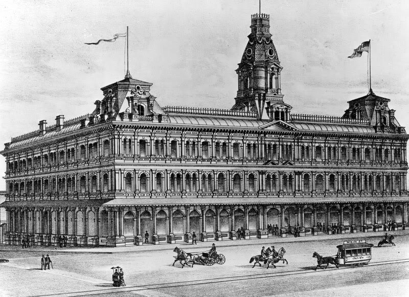
The Baker Block


Los Angeles Public Library Photo Collection/Litho. C.L. Smith & Co., Oakland, CA.


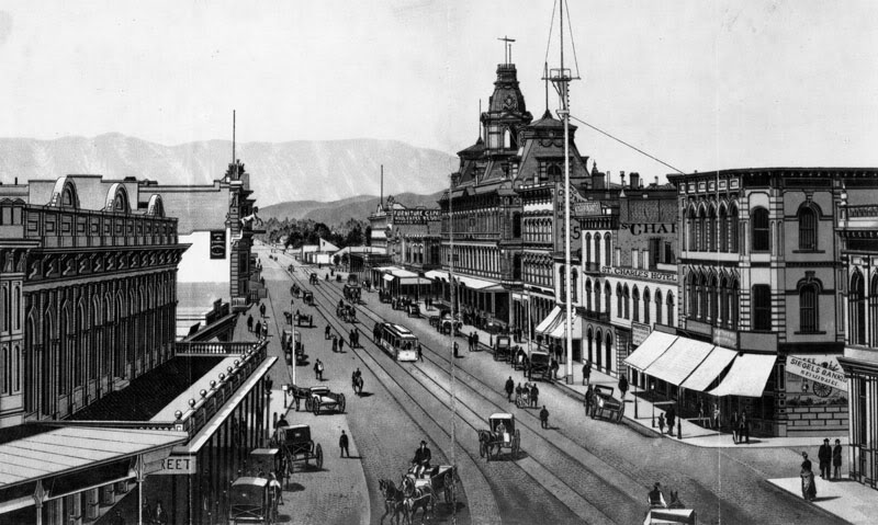
The Baker Block was the architectural showpiece of Los Angeles during the city's centennial decade. In a town still consisting mostly of simple frame houses and adobes, this palace of commerce must have been a truly wondrous apparition. Standing for 65 years – from c.1877-1942 – the Baker Block was located at the southeast corner of Main and Arcadia Sts., only a few hundred feet south of the original Pueblo de Los Angeles. An excellent summary of the history of the Baker Block can be found on Brian Hsu's Urban Diachrony weblog. Here are some pictures of this grand old edifice.

Main Street looking north from atop the Temple Block, c.1880; the Baker Block just right of center. (This vantage point is now occupied by City Hall.)


Los Angeles Public Library Photo Collection.


The uptown commercial heart of the old city, c.1880. The Baker Block at left, and the old Bella Union Hotel building at far right.


Los Angeles Public Library Photo Collection.


Southeast corner of Arcadia and Main Sts., 1880.


Los Angeles Public Library Photo Collection.


Fifty years later.


Los Angeles Public Library Photo Collection.


c.1920.


Los Angeles Public Library Photo Collection.


1938. There goes the neighborhood: the new Federal Building begins to rise across Main Street.


Los Angeles Public Library Photo Collection/Herman Schultheis, Photographer.


Not long for this world, c.1940.


Los Angeles Public Library Photo Collection.


Today, the 101 "Slot" runs right through the site where the Baker Block once stood...


Friday, August 12, 2011

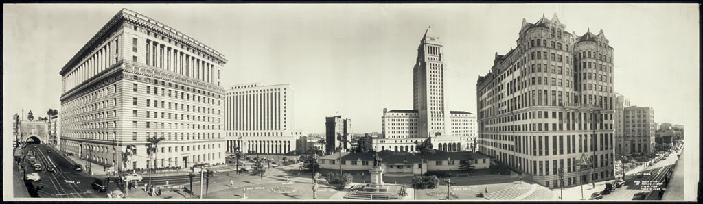
Civic Center panorama, 1946

The Los Angeles Civic Center, viewed from Broadway, March 11, 1946.


Source: Library of Congress.


Link to full-resolution TIFF file at loc.gov (4.6 MB).


Wednesday, August 10, 2011

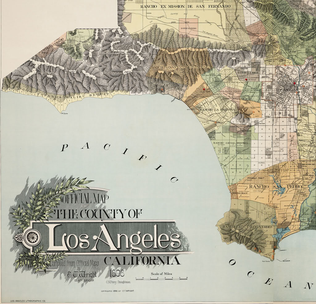
Rancho lands in 1898

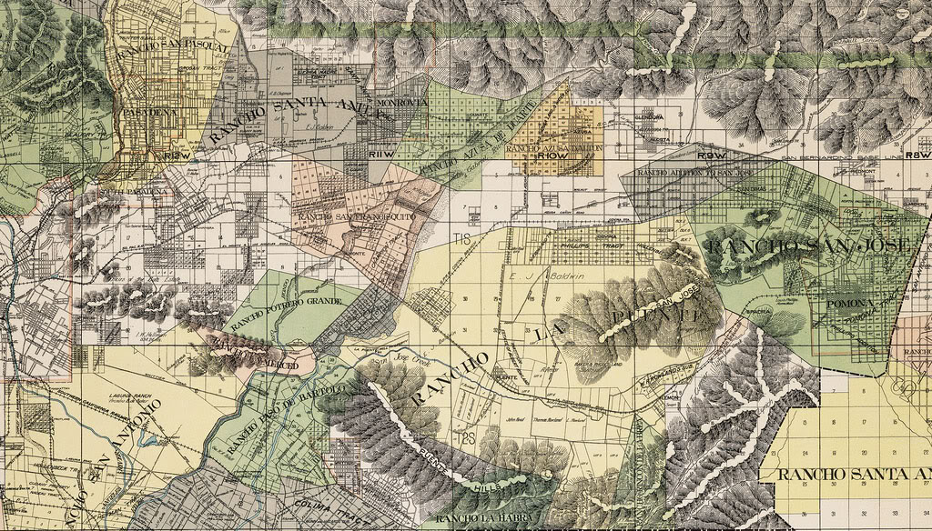
These highly-detailed maps show the boundaries of the former Spanish land grant Ranchos around Los Angeles County in 1898. Click on the link at the bottom of each map below to examine them closeup.


calisphere


Here is the section covering the San Gabriel and Walnut valleys. This one actually interests me more, personally, because this is the part of L.A. County that I grew up in.


calisphere


I hope you enjoy them. I can study these maps for literally hours on end...


Tuesday, June 7, 2011

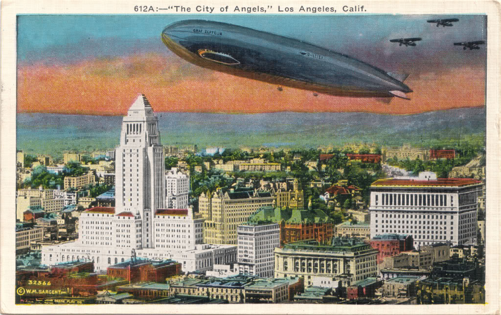
1929 Postcard


I've wanted this particular postcard for a long time, and now I finally have one of my own. The coloring is way off, but the aerial perspective of the Civic Center in 1929 is great. What's most striking to me isn't the Graf Zeppelin; it's that City Hall (left) and the Hall of Justice (far right) are the ONLY two buildings in this entire view that are still standing today. Everything else – every structure, tree, even the hill just beyond the Civic Center – is gone off the face of the earth. And this is Progress!


Wednesday, May 4, 2011

Urban Diachrony blog

Just wanted to put in an enthusiastic plug for a relatively new L.A. history blog called Urban Diachrony. Its principal subject matter is "Then & Now" photographs of various locations within the city.

The blogger, Brian Hsu, not only does an excellent job of taking his "Now" photos from the exact same vantage point as "Then," his accompanying descriptions are very detailed and always interesting. I learn something new about L.A. history with every post. Definitely check it out! I guarantee you will find it worthwhile.


I'm going to have cataract surgery on my left eye tomorrow. Hopefully I can start posting to my own blog more often after I get my normal vision back. This bad eye of mine has been a real impediment to me in recent months...